
- Details
Our group started a new cooperation with an Armenian institution. The project ML4GEO or "Capacity building of using machine learning for processing geospatial data in environmental investigations" aims at dеveloping the capacity of the Center for Ecological-Noosphere Studies of the National Academy of sciences of Armenia (CENS) in using the innovative technological approaches toward machine learning for processing geospatial data on earth observations in environmental investigations.
The Armenian state-funded initiative ML4GEO launched on 1st Oct 2020 in Yerevan, Armenia. This ground-breaking initiative envisaged an international collaboration with the University of Pavia in Italy. The bilateral cooperation has been in place since 2016 and a collaboration agreement was concluded in 2019 between the two organizations envisaged the development of joint scientific projects, staff retraining. The CENS team is happy to develop in ML4GEO joint investigations with Professor Fabio Dell'Acqua from the Department of Electrical, Computer and Biomedical Engineering, University of Pavia, as a leading scientific adviser of the project. His great experience in space-borne Earth Observation and Geoinformatics domain will help not only retrain young specialists of the GIS and RS Department of CENS reinforcing their research and networking skills but also pave a bridge for a long-term partnership between two leading research and education organizations.

- Details
Fabio Dell'Acqua was invited to give a talk at the educational workshop “Satellites Improve Life” in the framework of the Space School educational initiative by the Bulgarian Academy of Sciences and the Bulgarian Astronautical Society. This event is a part of the calendar of the World Space Week, which is celebrated every year from 4 to 10 October, under the auspices of the United Nations (https://www.worldspaceweek.org/events/event-list/). The event aims at highlighting the importance of satellites and their role and application in various fields of science, education, economics, business, as well as in many areas of our everyday life. 58 higher education institutions in Bulgaria have registered to attend. Prof. Dell'Acqua's talk will be given online on the 9th of Oct, 2020 at 11 am CET. For details on how to attend, please see the Kiro Page of the Geospatial Data Processing course.
- Details
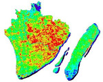
In the early 2000s, the German Aerospace Agency (DLR) was developing innovative hyperspectral optical sensors in preparation for future space missions. To this end, it involved the scientific community by launching an "idea contest" for researchers (see this heritage publication). The object of the competition was the identification of sites on which to carry out "test" acquisitions with prototypes of sensors mounted on an aerial platform. The request obviously had to be justified with the intended use of the data, and with the characteristics of the observed area in relation to the applications of the future space mission.
Prof. Paolo Gamba, coordinator of the Remote Sensing Group at our university, prepared a proposal entitled "Hyperspectral data exploitation for urban land cover analysis”. The proposal was one of the 8 selected out of the 22 received by the German Agency. On 8th July, 2002, a DLR aircraft equipped with two hyperspectral sensor prototypes flew over the city of Pavia and over the Cravino Campus carrying out the acquisition of data on two different urban environments, namely the city center and university facilities. Over the years, these data sets have become a reference point for the international satellite remote sensing community; see the “GRSS Data and Algorithm Standard Evaluation website” portal of the IEEE.
Recently, however, the “Cravino” hyperspectral dataset has taken an extra step: Mathworks, the company that maintains and distributes the famous scientific computation software MATLAB, has decided to use them in their tutorials on the new "hyperspectral toolbox"!
If you wish to see the Cravino Campus as it appeared in 2002 to a hyperspectral sensor, you can look at the MATLAB tutorial pages:
https://it.mathworks.com/help/images/hyperspectral-image-classification-using-abundance-maps.html
https://it.mathworks.com/help/images/target-detection-using-spectral-signature-matching.html
Once again the city of Pavia rises to the chronicles of international remote sensing scientific arena, after appearing in the communication of the European Space Agency regarding the "take-off" of the European satellite Sentinel-2.
- Details
The LoRa technology was developed to enable low-power, high-range wireless sensor transmission. Two recent papers from the research group at the TLC&RS lab [1,2] have shown that a simple RSSI-based method can be used for localizing LoRa IoT sensors. Article [1] has been one of the most read paper of the Wiley Internet Technology Letters in 2018-2019, and recently the dataset used in this work has been included in the 2020 GitHub Archive Program. Details of the two papers follow.
- Details
On Wed. 22nd July 2020 a webinar will take place to present Leonardo Company and the opportunities of masters thesis offered to masters students of Electronics Engineering.
This is the planned agenda:
10:45 - 11:00: Presentation of the company Leonardo s.p.a.
11:00 - 11:30: Presentation of avionic/space products
11:30 - 11:45: Presentation of available thesis topics (Nerviano site, near Milan)
11:45 - 12:00: Q&A
The link to connect to the webinar is reported below:
- Prof. Gamba attends the IEEE Microwave Theory and Techniques Society AdCom meeting
- Seminar at CNR on "Urban remote sensing by data fusion of radar and spectral data"
- Prof. Gamba presents at a workshop on “infrared remote sensing and applications”
- Prof. Gamba meets the Japanese emperor at IGARSS 2019